3 Bay Area roads among 10 deadliest in California
By Kellie Hwang
Three stretches of highway in the Bay Area are among top 10 deadliest roads in California, an analysis of federal data shows, with the recent unusual late-summer rain, expected to linger through at least Tuesday, among the factors that experts say increase risks for drivers.
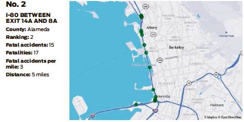
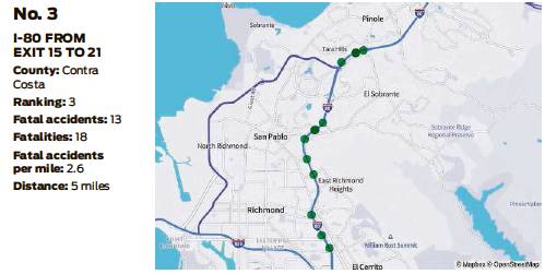
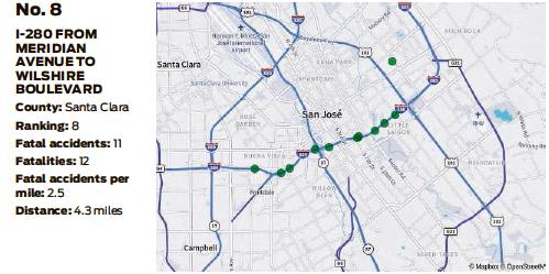
Two sections of Interstate 80 in the East Bay and a portion of Interstate 280 in the South Bay have among the highest rates of fatalities per mile in the state, according to a report from personal finance website MoneyGeek.
The report looked at car crash fatality data from the National Highway Traffic Safety Administration, analyzing more than 4,400 out of the nearly 400,000 roads in California of all types including highways, county roads and local roads. The report examined 10,370 fatal car crashes from 2017 to 2019, the most recent data available to analysts, identifying the deadliest road in each California county.
Among those, the portion of I-80 from Emeryville to Albany was the second most deadly in the state, with 3 fatal accidents per mile, and I-80 from El Cerrito to Pinole was the third deadliest, with 2.6 fatalities per mile. The portion of I-280 from Meridian Avenue to Wilshire Boulevard in San Jose was the eighth deadliest, with 2.5 fatalities per mile.
The deadliest road in California, according to the analysis, is the portion of Interstate 15 from exits 129 to 138 in Hesperia, 35 miles north of downtown San Bernardino, with a rate of 4.2 accidents per mile. A stretch of highway in Sacramento came in fourth, with 2.5 accidents per mile on Interstate 5 between Del Paso Road and Railyards Boulevard.
All other roads among the 10 deadliest were in Southern California.
The most common causes of fatal car crashes across the state are speed, drunken driving and distracted driving, according to MoneyGeek analysts. Other frequent causes include careless driving and driver error, as well as weather conditions like rain and wind, according to federal data analyzed by the Insurance Information Institute.
Across the United States, the month with the highest rate of fatal crashes is November, the MoneyGeek report said — which analysts attributed to holiday travel.
The report compared the state’s three largest metropolitan areas — Los Angeles, San Diego and San Francisco — and noted that while the San Francisco metro’s population is less than half the size of Los Angeles’, it has several roads that are deadlier in terms of concentrated fatalities.
The two roads in the Los Angeles metro that ranked among the top 10 deadliest were a stretch of Interstate 605 in Norwalk/Cerritos at No. 7, and a portion of Highway 22 in Garden Grove at No. 10.
But Doug Milnes, head of data and analytics for MoneyGeek, said it’s important to note that overall, “there are more driving-related deaths in the Los Angeles metro area at 4,628 fatalities, compared to just 1,292 fatalities in the Bay Area.”
Viewed as a per capita rate, “the Los Angeles metro area’s 35 driving-related fatalities per 100,000 residents is significantly deadlier than the Bay Area’s 27.3 driving-related fatalities per 100,000 residents,” he said.
The analysis did not look at the specifics of each road identified in the data; Milnes said many variables are at play that can make a road particularly dangerous.
“One reason pointing to why the Bay Area roads might stand out is that they serve as entryways to commuters getting into San Francisco and Berkeley, while the most dangerous metro L.A. roads run outside of Los Angeles proper,” he said.
Kellie Hwang is a San Francisco Chronicle staff writer. Email: kellie.hwang@fchronicle.com Twitter: @KellieHwang
“One reason pointing to why the Bay Area roads might stand out is that they serve as entryways to commuters getting into San Francisco and Berkeley, while the most dangerous metro L.A. roads run outside of Los Angeles proper.”
Doug Milnes, head of data and analytics for MoneyGeek