11th Street changes aim to bolster safety
By Dug Begley STAFF WRITER
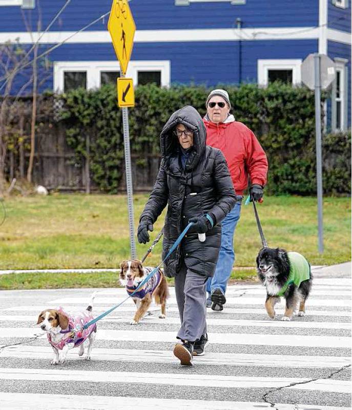
People cross 11th Street at Nicholson as they walk Thursday along the Heights Hike and Bike Trail. A city proposal would increase pedestrian and bike safety while reducing vehicle lanes.
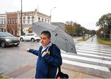
David Fields, the city’s chief transportation planner, stands last week at 11th and Nicholson streets.
A main thoroughfare through Houston’s Heights is the latest street where city officials are preparing for fewer car lanes, in an effort to consider more ways that people get around.
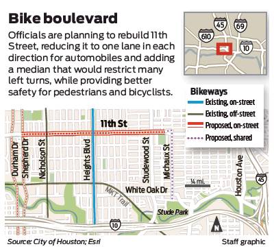
The plan by the city’s planning and public works departments is to transform 11th Street from two vehicle lanes in each direction to one, with bike lanes and occasional turn lanes.
The changes, which city officials argue will not severely impact drivers but will provide huge safety benefits, come as many communities struggle to improve sidewalks and smooth barriers to the use of bicycles and wheelchairs along roads while also providing capacity for cars. A recent plan for Broadway in San Antonio, for example, pitted city and state officials against each other last month over what is the best design for the street.
In Houston, while some have voiced skepticism, there is less political maneuvering, as many concede changes are needed along some streets.
Convenient, safe options for walking, running or bicycling in the Heights all run into the same problem as local drivers: 11th Street.
Lined mostly by businesses between Shepherd and Studemont, the street acts as the main east-west road for the neighborhood. Other streets may cover some of the neighborhood, but 20th is the only other major roadway that runs the entire width, mostly straight, with few stops.
As a result, drivers on 11th tend to hit the gas.
“People drive way too fast,” said David Fields, chief transportation planner for Houston, noting average speeds on the street often top 40 mph.
For folks trying to cross at the Heights Hike and Bike Trail near Nicholson, that can pose problems.
“Never mind stopping, people speed up,” Scott Bottoms, 36, said as he waited to cross 11th Tuesday afternoon on his way back to his townhome.
Paint and signs warning drivers to look for cyclists and runners have done little to dissuade faster drivers, leading officials and the neighborhood to seek more permanent ways to handle traffic. Getting to a final design has been time-consuming. City officials in 2017, as part of Houston’s long-range plan for bike amenities, proposed to narrow 11th to one lane in each direction and build a bikeway, a separated lane for cyclists, similar to those recently added to Austin Street, Gray Street and Waugh.
Houston officials will debut updated plans for the road Monday during an online meeting with Heights neighborhood groups. Design of the road is not complete, so construction timing and cost are not finalized, Fields said.
With the exception of 45 minutes during the evening commute when officials concede traffic backups are likely, a single lane can handle the current and predicted traffic demand. That bit of gridlock, city officials argue, is a valid tradeoff for major gains in safety.
Not everyone is convinced. During online discussions of the project in November and comments posted in December on the city’s feedback site for the project, various commenters questioned the theory that two lanes could handle the driver demand. Some suggested slower traffic on 11th would increase traffic on nearby streets with few stop signs, such as 14th Street.
Plans also call for a median along 11th at Nicholson that would allow runners, walkers and cyclists to cross one direction of traffic and then have a safe place to allow traffic going the opposite direction to clear. Users of the Heights Hike & Bike trail have said a so-called refuge island would dramatically improve safety. The median would be similar to those installed by Metropolitan Transit Authority along Studewood as part of its plan to improve shelters and crossings along some key bus routes.
The median, meanwhile, would restrict access to left turns and across 11th for many drivers, something Fields said led to some redesigns. At least four streets will have access straight across 11th, between Yale and Shepherd, while others could be added as planners finalize the design.
Some of the biggest coming changes, however, will be at major intersections where the city is hoping to eliminate conflicts. Traffic along Yale is unaffected, but the planned street redo removes left turns at Heights from all directions. The ensuing lack of left turns could send traffic circling onto nearby streets and force drivers familiar with the area to alter their habits.
Planners defend the decision as one that de-complicates common collision points in the neighborhood. Bike lanes, turning drivers, runners along the Heights Esplanade and proceeding traffic make for a variety of movements, which leads to confusion and close calls, although only a few dozen crashes in the past decade.
Fields said officials still are trying to resolve concerns about sending traffic onto side streets, but they will not sacrifice significant safety gains for ease for drivers. The hope, he said, is to balance both, for all road users.
“When we can do something that checks all those boxes, then we think the community will embrace it,” he said.
The planned bike lanes would add to a growing network around the city, including some major lanes planned for adjacent streets. Using federal funds, city officials are preparing to remove one lane on Shepherd and one lane on Durham between Loop 610 and Interstate 10 to add bike lanes along the busy streets.
When all of the projects are completed, possibly within five years, they will form the backbone of a system through the neighborhood and link to major transit routes along I-10 and Studemont via protected bike lanes.
Meanwhile, other communities are struggling to add bike and pedestrian access because of the perception those additions will take space away from cars. After months of planning, San Antonio’s plans to remove a lane along Broadway in the Alamo city were dashed when the Texas Department of Transportation re-asserted its rights to control the design of the road. In rescinding the city’s authority, Texas Transportation Commission members said the project reduced vehicle capacity, something they could not accept when the vast majority of Texans drive.
“What we’re trying to do is stay consistent with our congestion relief initiative and not go backwards by reducing capacity,” commission chairman and San Antonio financier J. Bruce Bugg said. dug.begley@chron.com