CLIMATE CHANGE
WASHED AWAY
Rising water in R.I. begins to erode worth of coastal homes
By Alex Kuffner Journal Staff Writer
PROVIDENCE — Rhode Island’s real estate market is already feeling the effects of climate change.
That’s according to new research released on Tuesday, which found that the values of coastal properties are lagging the rest of the market because of the increased risk of tidal flooding connected to sea-level rise.
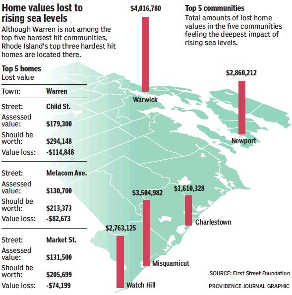
All told, home values in the Ocean State lost $44.7 million in appreciation between 2005 and 2017, according to the study by a team from Columbia University and the First Street Foundation.
The study analyzed values for 2½ million coastal properties in Massachusetts, Maine, New Hampshire and Rhode Island, estimating the total loss in the four states at $403.1 million.
For one house on a flood-prone stretch of Child Street in Warren highlighted in the report, the effect was profound. The home was assessed at $179,300 but would have been worth $294,148, or 64 percent more, if it had been on higher ground, according to comparisons with similar homes.
“Most homes are increasing in value,” said Jeremy Porter, a lecturer in environmental health studies at Columbia who co-led the study. “What we’re finding is a gap in appreciation.”
Combined with previous work that looked at housing values in Connecticut, New York and New Jersey, the Southeast and the Gulf Coast, the First Street/Columbia researchers have estimated losses caused by rising seas at a $15 billion across 14 coastal U.S. states.
The new research comes weeks after the release of the 2018 update to the National Climate Assessment, which in large part focused on potential economic losses tied to climate change, warning that sea-level rise could exacerbate storms, floods and erosion, and threaten the nation’s $1-trillion coastal real estate market.
By 2050, as much as $106 billion worth of real estate could be below sea level, according to the assessment compiled by 13 federal agencies. And by the end of the century, the number could rise to $507 billion.
In another report released last year, the Union of Concerned Scientists projected that 300,000 coastal homes worth $117.5 billion could be at risk of flooding every other week by 2045.
But the new research found that negative effects on the property market aren’t just future possibilities.
“Lots of analyses have shown that there will be an impact. We’ve shown that there is already water in the streets,” said Porter, who partnered on the study with Steven McAlpine, head of data science at First Street Foundation, a New York nonprofit group focused on communicating flood risks caused by climate change.
Because of changes in ocean currents, water temperature and other factors, seas are rising faster in the Northeast than just about anywhere else in the world. A recent study by the National Center for Atmospheric Research estimated that cities in the region could experience more than double the global mean average for sea-level rise over the next two decades.
From 1930, sea levels in Rhode Island increased by about an inch a decade, until about 40 years ago when the rate started to accelerate. The state has seen 6 inches of sea-level rise since then.
The Rhode Island Coastal Resources Management Council has adopted projections by the National Oceanic and Atmospheric Administration to plan for up to 11.5 feet of sea-level rise by the end of the century.
“Lots of analyses have shown that there will be an impact. We’ve shown that there is already water in the streets.”
Jeremy Porter, lecturer in environmental health studies at Columbia University
The CRMC has worked aggressively in recent years to prepare the state for higher seas, developing online mapping programs, such as STORMTOOLS, so homeowners can better understand the threats and the tightening of regulations on building on the coast.
CRMC executive director Grover Fugate said the Columbia/First Street study appears to be consistent with research done by his agency as well as the University of Rhode Island.
Porter and McAlpine combined records on tidal flooding with property market data. They compared home sales and factored in differences between properties to isolate the impact of flooding. They chose 2005 as the start of the study because that’s when they noticed a sharp increase in so-called nuisance flooding events.
According to the study, the hardest-hit community in Rhode Island has been Warwick, which is relatively low-lying and has a long stretch of coastline. Watch Hill and Misquamicut in Westerly aren’t far behind. Newport and Charlestown round out the list of the top five places that have felt the deepest impact on property values.
But it’s Warren, in the area around the Palmer River and Belcher Cove, where the houses that saw the largest relative loss in value are located. Besides the house on Child Street, the researchers pinpointed homes on Meta-com Avenue and Market Street whose assessed values are at least 50 percent below where they would otherwise be.
The findings could have implications concerning mortgages and insurance rates for homeowners, but also for cities and towns, which rely on property-tax revenue. With the study and the Flood iQ online tool that maps the results, First Street is trying to educate people and communities about the risks of sea-level rise and help them make decisions for the future, said Matthew Eby, executive director of the foundation.