TxDOT is increasing freeway drainage flow
Detention basins, pumps form system to keep cars moving
By Dug Begley STAFF WRITER
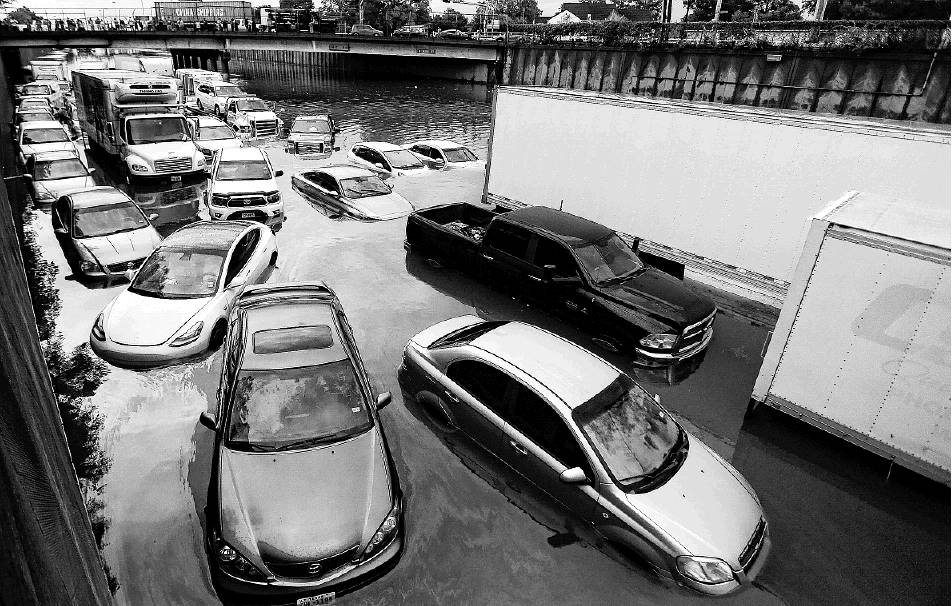
Flooded vehicles on southbound Interstate 45 near Main Street are abandoned after the remnants of Tropical Storm Imelda made their way through Houston on Sept. 19. Some low-lying sections still flood in heavy storms despite TxDOT’s massive drainage system.
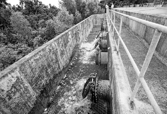
Water is discharged Monday through pipes at the Texas Department of Transportation pump station at Interstate 10 and Patterson Street in Houston.
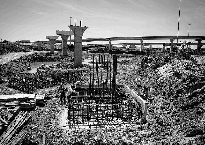
A new detention pond is built in March underneath what will be a flyover from Loop 610 to the new tollway along Texas 288. The low-lying area is notorious for flooding.
A pump station is a much different place when it is not raining. There is an occasional ripple or drip somewhere in the massive cavern that acts as a well for the machinery meant to keep Houston freeways clear.
The whir of passing traffic on a Monday morning drowns out any other activity at the pump station tucked between Interstate 10 and White Oak Bayou. Then, John Stobb, a hydraulics pump mechanic with the Texas Department of Transportation, pushes a button and everything changes.
There’s arumble, then a clang as air and then a rush of water pours from a large pipe a few feet below, beginning its long trip to Buffalo Bayou and then Galveston Bay.
Four days prior, the station was roaring, until it wasn’t, when White Oak Bayou reached its capacity to contain the remnants of Tropical Storm Imelda. With nowhere to put the rain, it remained on the freeway, an increasingly common occurrence during some of Houston’s harshest storms.
It is not for lack of horsepower to heave water off the road, TxDOT officials said. It simply is a matter of too much rain falling too quickly for the drainage system to keep up. What stops the system from handling the storm is not the power to pump rain off the road — it is where to put that water.
“That’s where we have the problem here,” said Elie Alkoury, hydraulics engineering supervisor for TxDOT.
It is a problem TxDOT officials said is forcing them to build bigger detention basins, as well as larger underground storage cisterns in major projects, such as the Loop 610 and Interstate 69 interchange, new toll lanes along Texas 288 and a massive planned rebuild of Interstate 45.
“We’ve got about every hydraulics guy in town working on it,” James Koch, director of transportation planning and development for TxDOT’s Houston office, said of the I-45 project.
Moving streams
The pump station at Patterson and I-10 is among the largest in TxDOT’s Houston’s region with eight pumps, each capable of moving 20,000 gallons of water a minute. If all the pumps are operational, the station throws an Olympic swimming pool of water into White Oak Bayou every four minutes.
That makes quick work for water during flooding, and a fast return once bayou levels begin to lower. By Friday, 24 hours after Imelda’s deluge, I-10 through the Heights and Rice Military was flowing with cars, not storm runoff.
“If this pump station wasn’t here, we would still be looking at water over I-10,” Koch said.
The pump station is the end of the line for pipes and drains along a mile-long depressed section of the freeway. Rain comes down on the freeway, flows to an inlet and is carried by culverts and pipes to this low-lying spot near Patterson, down a no-outlet street from Houston’s traffic operations center.
Once water reaches the site, it is stored in the well, a four-story reservoir in a concrete box. The structure is divided by metal grates along its top and at intervals within it. The grates catch all of the trash that floats in with the rain.
Stobb noted pump stations around the area vary in terms of cleanliness. On this stretch of I-10 litter is not an issue. Along I-45 south of downtown and a few other places, the foam cups from fast-food restaurants and discarded cans can really pile up.
When water reaches a certain level in the reservoir, the pumps kick on, drawing the water from the bottom where it largely is free of grime. The force of the pump pushes the water up via pipe, where it pours into an outfall and then flows through a culvert down to whatever body of water handles drainage in the watershed.
Comparisons to a bathtub get thrown around a lot talking about flooding in Houston: Engineers can build the pumps and drains to let the tub take in water, hold it when they want to and then pull the plug and have the water go away.
It is not that simple, however. When the pipes back up — in the case of Houston, the bayous that carry water away — then the tub does not drain. Named storms like Harvey and Imelda inundate some spots so fast that nothing will keep the water moving out faster than it is falling.
It often means the same outcome for certain spots during normal heavy rains. They have flooded so often drivers come to expect it: Interstate 45 at North Main, Texas 288 at Loop 610, I-10 at Shepherd.
“I knew (I-45) was flooded before I left my house,” Woodland Heights resident Steve Schaffer said of Imelda’s deluge on Sept.
19. “Based on the rain, I knew it had flooded.”
Dozens of cars were flooded in a flash as waters rose on the freeway. At 1:20 p.m. that Thursday, White Oak and Buffalo Bayou peaked above flood stage. Adding pumps would not have helped.
While failures to handle the flow get the spotlight, less attention is paid to places where things work as intended. Despite also receiving torrential rains during Imelda, depressed portions of I-69 stayed open because of the massive pump operations that clear the freeway. Huge detention basins meant to hold water when it has nowhere to go helped clear I-45 north of Houston as other parts of the region were swamped.
Koch said the Houston region’s flood control should not be judged on one area, but whether the entire system is functioning for the best outcome, even if that leads to difficulties in some spots. During Harvey and Imelda, the depressed portion of I-10 became impassable for hours — in Harvey’s case, days — as stormwaters overwhelmed the watersheds.
Flooding the freeway, however, likely held back water from hitting homes.
“We can engineer solutions,” Koch said. “The challenge is to explain it to folks that it has to work as an entire system.”
Bigger is better
Even before Harvey hit Houston, there was some movement to beef up flood protection in certain freeway projects. Texas 288 and Loop 610, a notorious flooding site because of a lack of adequate detention at the low-lying location, is being rebuilt as part of a $2.5 billion private toll project. The project roughly doubles the capacity of the detention basins surrounding the interchange.
“Doing the drainage part allows it to take more time to let everything work its way down,” said Raynese Edwards, spokeswoman for the Texas 288 project, during an April tour of the site.
Though much of the project site remains a muddy area, the detention is noticeable, essentially two man-made lakes that spring up beside and below the freeway to keep it clear. A large box culvert beneath the freeway connects the ponds, which eventually feed all that water into Brays Bayou.
Alkoury said standards have led to larger detention and more pumping capacity on many projects. Technically, TxDOT is responsible only for handling its own runoff issues, but on some projects, such as the Loop 610 and I-69 interchange, officials believe runoff is coming from adjacent properties —among them the Houston Chronicle offices — for which it must account.
More rain in stronger bursts also is a reality, Alkoury said.
The National Oceanic and Atmospheric Administration last September redefined how much rainfall it takes to qualify a storm as a 100-year event, one that has a 1 percent chance of occurring in any year. The previous definition of a 100-year event in Houston was 12 inches of rainfall in a 24-hour period. The new definition raises that to 18 inches in a 24-hour period.
“The new 100-year flood is more like 18 inches, which is almost the old 500-year level,” Alkoury said. “That’s how the system has to work right now.”
The system also works with a lot of backup and redundancies. For example, in the event power goes out, the Patterson pump station along I-10 has two 1-megawatt generators — each the size of a garbage truck — that turn on. The diesel generators have expanded tanks capable of delivering enough fuel to run the plant for two or three days. Trucks can drive in more fuel if needed, Stobb said.
For the most part, pump stations operate on their own, with overseers such as Stobb swinging by weekly to verify everything is in order. As storms approach, mechanics may take afew more precautions.
The pump machinery is routinely maintained and lasts decades.
“We have a pump station that has a pump in it, and it’s been working for 50 years,” Stobb said, adding that pumps typically are replaced when they become so old that routine parts stop being produced.
Houston’s ‘Big Dig’
Nowhere are the eyes of TxDOT officials and the public more focused on flooding than the proposed I-45 project from downtown Houston north to the Sam Houston Tollway.
“We have developed a drainage plan to neutralize the impacts,” TxDOT Houston district director Quincy Allen told city officials in June.
One reason for that is necessity. The project, estimated to cost at least $7 billion, would shift I-45 from the west side of the central business district to the east side, taking the freeway along the same path as I-69. Both freeways would be below street level for about 12 blocks, and possibly capped by a park.
I-69 in Midtown and I-45 north of downtown also would be depressed for longer distances, and potentially capped with green-space or other amenities. Though some have welcomed the chance to bury the freeways to reduce noise and blight in some areas, the plans to put key freeway routes below local streets have led to fears of further flooding.
“They are going to turn these freeways into detention ponds,” Midtown resident Jim Honey said. “You cannot have people trapped in these below grade freeways. …You are quite possibly going to kill people.”
Officials have said such fears are unfounded and that the project provides solutions for many local drainage problems. The potential caps, which would require others to pay for construction of greenspaces or other amenities while TxDOT would build the project to support something atop it, actually could improve drainage, Alkoury said.
“We can put the drainage on top,” he explained, adding engineers would have to factor only for water entering at the ends. Then all of the drainage could converge at a low-lying place where it probably would run into Buffalo Bayou.
Reiterating their point that everything works as part of a larger system, TxDOT officials noted they have added huge detention basins along I-45, including one that will take the entire Love’s Truck Stop site at Patton and I-45.
When it comes to flooding though, officials are not the only ones looking at the whole system and looking for assurances. Rebecca Reyna, executive director of the Greater Northside Management District, said TxDOT’s pledge to fix flooding on I-45 is welcomed by the community, if it does not have unintended consequences. The confluence of White Oak and Buffalo bayous has been a concern for years in the area.
“We’d rather see the freeway flood than the homes,” Reyna said. dug.begley@chron.com