THE CORONAVIRUS PANDEMIC
Steps you can take
R.I. hikes offer social distancing, antidote to cabin fever
By Alex Kuffner Journal Staff Writer
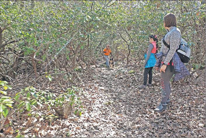
A family returns from a hike in Long Pond Woods, an Audubon property in Hopkinton. [THE PROVIDENCE JOURNAL / SANDOR BODO]
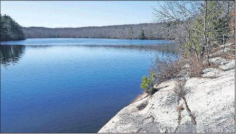
A view of Long Pond, in the Long Pond Woods in Hopkinton. [THE PROVIDENCE JOURNAL / SANDOR BODO]
In these days of social distancing, you may be going a little stir crazy — especially if there are kids in your home — and want to stretch your legs. Fortunately, Rhode Island offers lots of great walks outdoors within easy reach. Here are some places where you can get some fresh air and hopefully avoid the crowds:
The Sachuest Point National Wildlife Refuge in Middletown offers three miles of walking trails across 242 acres that sit at the mouth of the Sakonnet River. To get there, head down to the Newport beaches and bear east to pick up Sachuest Point Road. The refuge’s visitor center is at the end of the road.
The trails, which pass through grassy shrublands, are flat and easy to walk. If you want something more challenging or if you have kids who like to climb, find one of the paths down to the cobble beach. In amongst the craggy rocks and boulders, you’ll find tide pools to explore, and you may catch a glimpse of a harlequin duck, loon or gannet in the nearby ocean waters.
If you’re not tired yet and want to continue walking the shoreline, Second Beach is just down the road and offers easy strolls along its sandy expanse. Or if you want to get into the woods, the Norman Bird Sanctuary and its seven miles of trails is a five-minute drive away. The sanctuary announced that it’s staying open but is asking visitors to buy passes online or by phone beforehand.
Another great place to walk along the shoreline is Napatree Point, a sandy peninsula in Westerly at the mouth of Little Narragansett Bay. Park in the village of Watch Hill, walk past the Watch Hill Yacht Club, and you’ll find the entrance to the Napatree Point Conservation Area, 86 acres of protected land managed by the Watch Hill Conservancy.
Designated a “Globally Important Bird Area” by the Audubon Society, the 1.3-mile-long spit of land is home to piping plovers, American oystercatchers and osprey. Trails on both the Bay and ocean sides lead out to the point, where you’ll find the ruins of Fort Mansfield, a short-lived military installation that was built in the early 1900s.
Napatree is not only a scenic place to visit. It also offers a lesson in the changing contours of the Rhode Island shoreline. Surges from hurricanes and other major coastal storms over the years have washed sand back over the point’s dunes onto the Bay side. Napatree isn’t necessarily getting smaller, but it is shifting north. The barrier has moved back one complete width since 1938.
For another view of the state’s coastline, go to 787-acre Trustom Pond National Wildlife Refuge in South Kingstown. The parking lot can be found off Matunuck Schoolhouse Road. Take the Moonstone Beach Road exit from Route 1 to get there.
Trails lead through fields and woods to Trustom Pond, one of a series of salt ponds along the state’s southern shore that were formed by the retreat of glaciers in the last ice age. Trustom is the only one that hasn’t had any development along its shores.
The refuge is considered one of New England’s best birding spots. There are viewing platforms around the pond to check out the many species of waterfowl that can be found in its waters this time of year.
If you want a more difficult walk, head over to Long Pond Woods, an Audubon Society of Rhode Island preserve in Hopkinton, where trails wind through forests of mountain laurel, rhododendron and hemlock.
To get there, take exit 3B off Route 95 to head west on Route
138. Take a left on Wincheck Pond Road, then another left on Canonchet Road, and then turn right on North Road. About a mile down the road, you’ll see a small parking area and the trailhead.
The out-and-back trail leads along the southern edge of the pond, but there’s an offshoot that takes you to a rocky outcrop on the pond’s north side that has great views of the water.
Be warned, the trail is rough in places, requiring hikers to climb and descend some steep hills and clamber over boulders. It’s worth it though for the natural beauty there.
Another hike that’s a bit easier leads up to Stepstone Falls in the Arcadia Wildlife Management Area, in West Greenwich. This is where the Wood River is just starting its long and winding journey to Little Narragansett Bay and the Atlantic Ocean.
To get to the trailhead on Plain Road, take Route 3 south in Exeter to 165 west and turn right onto Frosty Hollow Road. Drive to the end, then go left and after 2.25 miles cross the river and park just beyond the bridge at the right.
On the 1.3-mile journey up to the falls, you’ll walk through forests and cross streams and get a sense of why the Wood-Pawcatuck watershed is the only one in Rhode Island to be designated a “National Wild and Scenic River.” The trail along the river passes an old stone quarry, the remains of a gristmill and an earthen dam that was part of the mill and the ruins of a sawmill.
You can take half a day or more for all of these hikes, but there are plenty of great walks that you can do in an hour or two, from the Queen’s River Preserve in Exeter, which offers views of one of the most pristine rivers in the state, to the Audubon Society of Rhode Island’s Touisset Marsh Wildlife Refuge in Warren, which has a small yet scenic salt marsh on the Kickemuit River.
For more ideas, check out the websites for the state park system, the Rhode Island Land Trust Council, which has links to land trusts in cities and towns that maintain trails, the Audubon Society of Rhode Island or The Nature Conservancy’s Rhode Island office. akuffner@ providencejournal.com
(401) 277-7457 On Twitter:@KuffnerAlex