‘Shared vision’ on 6-10 would open some land to new development
By Patrick Anderson Journal State House Bureau
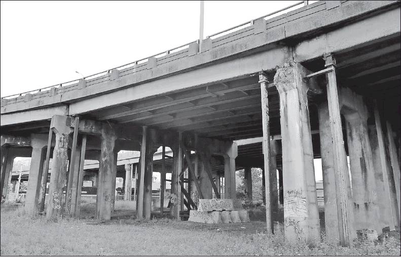
Temporary shoring holds up a section of the Routes 6-10 overpass near Magnolia and Troy Streets in Providence. A compromise plan on the reconstruction of the highway was unveiled Thursday. PROVIDENCE JOURNAL PHOTOS/KRIS CRAIG
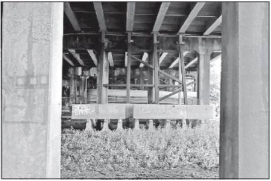
The poor condition of the Routes 6-10 connector has the state fast-tracking its reconstruction.
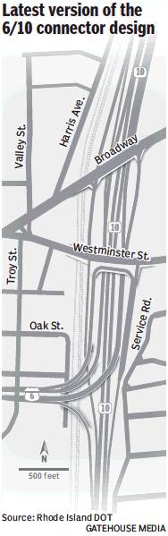
PROVIDENCE — City and state leaders Thursday unveiled a new design for the antiquated Routes 6 and 10 interchange that adds some of the neighborhood-friendly features Providence leaders have pushed for while keeping most of the current expressway intact.
Drivers worried about the unusual “halo” elevated rotary proposed by the city in October can relax. It’s been scrapped for an updated version of a traditional ramp.
And some land that city planners had hoped to reclaim from the highway by creating a narrower parkway will remain as it is.
However , the new “shared vision” described by Gov. Gina Raimondo and Providence Mayor Jorge Elorza would lower and shorten some of the crumbling elevated highway ramps that have separated neighborhoods such as Olneyville, Silver Lake and Federal Hill from each other and the rest of the city.
And changes requested by city planners, such as a bike path to Cranston and removal of two highway ramps, were added to the design while keeping within the state’s $400 million budget.
“We are keeping Rhode Islanders safe, which is the primary goal,” Raimondo said at an afternoon news conference. “We are improving bike lanes and making acres of land open for new development, stitching neighborhoods together and bringing down a highway that all of us agree is a good thing.”
State and local agreement on the design could end a lengthy debate about what to do with the 6-10 corridor, whose seven structurally deficient bridges have been called the worst spans in the state with the worst bridges in the nation.
A series of community groups pushed to tear down the highway and replace it with a surface boulevard and in March the state Department of Transportation proposed a below-grade concept for the interchange.
After failing to win a federal grant, Raimondo in September ditched that plan and, citing safety concerns, ordered an expedited rebuild of the current highway design, triggering the “halo” proposal from the city and then months of joint planning sessions. Replicating the interchange was also expected to cost $400 million.
The fruits of the joint planning effort will cut the length of the Huntington Avenue Viaduct, the overpasses now being shored up with braces, in half to make it less imposing on the adjacent neighborhoods.
And it adds a ramp along Westminster Street allowing drivers on Route 10 North to reach Route 6 West, the so-called “missing move” many blame for congestion in Olneyville Square.
The state adopted the city’s proposal to move the Tobey Street on-ramp south of the interchange, freeing up 1.4 acres for development and allowing Tobey Street to be converted into a two-way neighborhood road with a protected bike path. The current location of the on-ramp forces motorists to weave across traffic to access Route 10 South.
The new design would also eliminate the Plainfield Street on-ramp to Route 6, freeing up 3.4 acres of new real estate.
Finally, the new plan would add a bike path connecting Valley Street, via the rebuilt Tobey Street bridge, to the Washington Secondary Bike Path in Cranston.
What happened to the “halo?”
Raimondo said traffic models suggested it would slow traffic, a deal breaker for her.
Elorza said there were concerns big rigs could not make some of the turns on a narrower roadway.
That’s especially important because the project is being partially financed with money from the state’s planned tolls on large trucks.
State DOT Director Peter Alviti Jr. said he hoped to hire one firm to design and build the project in the next few months and break ground by the end of 2017. The entire project is expected to take five years to complete.
Reaction to the new design among community groups was mixed, but on balance favorable.
“Overall we are quite pleased,” said Seth Zeren, spokesman for the Fix the 6-10 Coalition. “It is not perfect. It is a compromise.”
Zeren said he liked the transformation of Tobey Street and that you wouldn’t have to walk under the highway to get from Federal Hill to Olneyville Square.
Jonathan Harris, an assistant professor in the Johnson & Wales University School of Engineering & Design and a member of pro-boulevard group Move Together PVD, said the plan is an improvement over rebuilding the highway as it is.
However, he said he was skeptical that Westminster Street and Broadway will become pedestrian friendly — and disappointed that the plan does not involve public transit.
—panderson@ providence-journal.com
(401) 277-7384
On Twitter: @
PatrickAnderso_